In September most of the cycling competitions are over and many cyclists let the season come to an end. At the same time, there are still summer temperatures and it is a good time to set off for the alpine regions with hiking boots and a backpack, since the snow has often melted at higher altitudes and the first onslaughts of winter often don’t bring a return of persistent snow cover until October. A great destination is certainly Germany’s highest mountain, the Zugspitze (2962 m altitude). Several routes lead to the Zugspitze. I have briefly outlined six tours here. The more detailed descriptions from other websites are linked. One of the tours I did in 2016 after my first Ötztal bike marathon. I can highly recommend this one especially to ambitious cyclists. And now have fun dreaming.
The longest route to the Zugspitze leads through the Rhine Valley. Many hikers make the ascent in two days and spend the night in the Rheintalangerhütte at an altitude of 1369 meters. Up to the hut are often also many mountain bikers on the way. The Partnachklamm gorge with the Partnach rippling along offers a beautiful atmosphere. The climb is considered the easiest and is just for less hikers (what a pun) well suited.
The most popular climb leads through the Höllental. The view is spectacular and the via ferrata a thrill. However, the popularity means that it quickly gets crowded on the trails and via ferrata, which is why many mountain enthusiasts avoid the tour on weekends.
Famously infamous is the Jubiläumsgrad, over which one approaches the Zugspitze from the east. The partly free climbing without belaying on the exposed rock is only something for experienced mountaineers. People regularly have fatal accidents there.
From the west there is also a demanding, though not so difficult climb. It leads from Ehrwald via the Wiener- Neustädter-Hütte to the summit. The short ascent is very steep and there are climbing passages without insurance and a regular via ferrata, the Stopselzieher via ferrata.
The climbing route Eisenzeit was made accessible again only a few years ago and leads through the north face. It is a combination of combined via ferrata and climbing route, which should only be used by very experienced climbers! Due to the danger of falling rocks in some sections, a helmet is virtually mandatory. The tour uses parts of the route of the builders of the Eibsee rack railroad.
My recommendation for cyclists: the Gatterl Tour
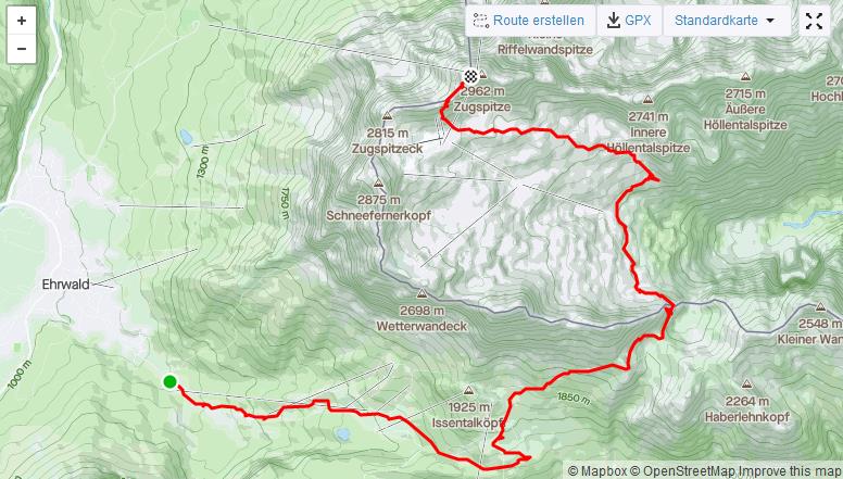
The last and sixth way to the summit leads across the border between Austria and Germany via the Gatterl. Therefore, the tour is often called the Gatterl tour. The Gatterl is a door of the border crossing. Thereby the tour exists both from Germany to Austria and vice versa. For “normal” mountain hikers, the tour is offered with the use of two mountain railroads. One is the Zugspitzbahn and the second is the Ehrwaldbahn. On the tour from the German side to Ehrwald in Austria, the route is almost always downhill. The most frequented version is the tour starting in Ehrwald. Those who want to walk the more leisurely tour with use of the Ehrwaldalmbahn can find a description here.
On the Komoot platform, the Gatterl tour without a train on the ascent is described as: “Difficult hike. Very good condition required. Good surefootedness, sturdy shoes and alpine experience required”. The walking time is estimated at over 7 hours. The GPS track can be downloaded from Komoot.
The Gatterl tour was a spontaneous decision for me after optimal weather. The ascent from Ehrwald is partly steep, especially where the Ehrwalder Almbahn also runs. However, this offers the possibility with appropriate condition to shorten the walking time considerably. 400 meters in altitude are doable in one hour at a basic pace. With appropriate speed/condition, the tour can be started in the late morning, which allows you to avoid the main traffic on arrival. Since the days get shorter in autumn and you always need a time buffer in the mountains, you have to hurry on the descent or – as is customary – use the cable car for the descent (note: last descent is in the afternoon). Since I like to avoid steep and long descents, as the knees are not insignificantly stressed, I chose the option of descending with the last Zugspitz cable car.
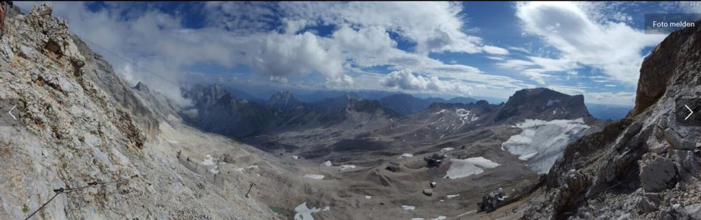
You can find the tour on my Strava account (here). Starting point was the valley station of the Ehrwalder Almbahn. The path was easy to find and was partly signposted. For the ascent I needed 5 hours walking time. In total, there was a good 2000 meters of altitude to climb. Shortly before the Gatterl it went on a saddle briefly something downhill and then in a short counter ascent of a few meters in altitude. On the Knorrhütte there was a break of three quarters of an hour for a piece of cake. Past the last remnants of the glacier, the tour led to the steep scree field below the summit. (The scree field could have been avoided by using the glacier cable car). After the scree was still waiting easy climbing with wire rope insurance and I soon reached the summit. With the last Zugspitzbahn it went down to the valley. I then took the bus back to the parking lot.